
A city intersection is usually considered a specific place, often a point of orientation, which is to say a unitary thing. But with a 360-degree perspective an intersection is a multifarious thing, the meeting point of four discrete blocks of land, each of which can have its own history and character. Such is the case with Beech and Pine.
The intersection lies near the centre of the Balmy Beach subdivision, the huge tract of land subdivided in 1876 by its longstanding nineteenth-century owner, Ontario Justice Adam Wilson, into 146 one-acre lots – ideal for summer villas his sales agent declared. Wilson’s vision of Balmy Beach as a villa community proved to be fanciful (See Sights #1 and #3) for although he and his partners did sell a few lots not one of the buyers built a villa. And after Wilson’s death (1891) most of the property owners, including his original business partners, further subdivided the lots down to about one-sixth the original size – better suited to the emerging middle-class housing market – and so began the process of creating the dense residential carpet that characterizes the Beaches today.

Showing villa-sized lots in the vicinity of Beech and Pine
It so happens that each of the four corners of Beech and Pine – Lots 62, 63, 94, and 95 of Wilson’s plan of subdivision – followed a different path to residential development, reminding us that the process of creating a suburban neighbourhood such as the Beaches was also multifarious. Furthermore, and quite remarkably, the retaining walls bordering each of these four properties are sufficiently intact to tell us something about the development path that each corner took.
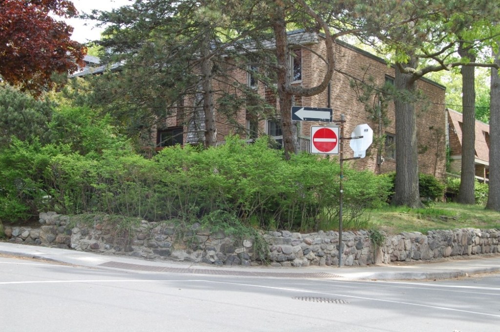
The NORTHEAST CORNER reveals Justice Wilson’s fanciful scheme more than the other three. For reasons that have escaped the historical record, the east side of Beech Avenue north of Pine was built up quite early in the development process, prior to any subdividing of the villa-size lots, and some of the early buyers put up substantial houses. None occupied an entire lot – more than one house could be, and was, built on a single lot even without further subdivision – but some were a good size, with generous setbacks and ample grass yards. It was no ‘millionaire’s row,’ but it did reflect, if only slightly, Wilson’s vision of an exclusive subdivision.
One of these good-sized houses was a two-storey wood frame and stucco-clad structure on the northeast corner of the intersection, facing Beech Avenue, built by John Elgin Snider, an enterprising salesman for a large commercial agency who went on to establish his own successful garment manufacturing firm. Snider bought Lot 62 from Wilson and his partners in 1887 and either acquired with the lot or had built a small, rustic cottage that he and his family used – they lived in the city, on Carlton Street – until about 1900, when he demolished the cottage and had the large house built as a year-round family home. The Sniders were fully settled in it by 1902.

The additional front stairway, built in later years, led to a separate ground-floor suite for an aged family member; the house originally had an unenclosed porch with a side stairway up to it.
Snider owned the entire villa-size lot, through to what would become Willow Avenue, and over the next few years two of his sons built houses for themselves and their families on the property – one on the lot’s northern edge, also facing Beech, and another on the lot’s eastern end at Willow, fronting on Pine, the latter, which still stands, looking somewhat like a scaled-down version of the main house. By 1910 Lot 62 had become essentially a Snider family compound, and so it would remain for three generations, with various family members living in the houses at different times. The eastern portion was sold off – its Pine Avenue house remained intact – but for all these years the main Snider property was not further subdivided or given over to mass-market housing. Finally, in the early 1970s, with the then-current generation lacking the means and inclination to do all the upgrades the aging houses needed, the family sold the entire property to a developer who demolished the existing structures and built the townhouses that occupy the site today. The twentieth-century Beaches finally arrived.
But the builder left the retaining wall intact. This wall, made of cemented large fieldstones, with stone pillars (now gone) at the pedestrian and vehicle entrances, was almost certainly built along with the original houses in or shortly after 1902, and since portions remain in front of the smaller house facing Pine it was evidently built to enclose the entire lot. Demarking one’s family property with a permanent stone wall suggests a lingering rural sensibility – Snider was raised on a farm – but is it not also an assertion of family accomplishment and significance, the latter a not uncommon sentiment in the 1890s among United Empire Loyalists, which the Sniders were. The Snider house was no villa, but the property’s stone wall, signifying Lot 62 as a quality family’s patrimony, speaks to us of the Balmy Beach villa community that never was.
The villa-size lots SOUTHEAST of the intersection were acquired and subdivided into fifty-foot lots by a pair of speculators in 1887, and four of these lots, numbers 31 to 34 – the last being the corner lot – were promptly purchased by George G. Jones, a bricklayer by trade who lived well west of the neighbourhood, on Logan Avenue. As did many enterprising tradesmen in these years, Jones bought this property as what would be called today a ‘developer’, and within two years he had seven houses on his four lots – a pair of semi-detached houses on three and a detached house on the fourth (Lot 33), the last being his own residence as of 1900.

Snider’s houses, on Lot 62, are shown here as well.
Whether Jones built these houses himself, we do not know. One suspects not. Tradesmen/builders often did their own building, but when they did they usually built similar houses, which these were not. We do know, however, that Jones retained ownership of them and rented them out as a source of income. In 1915 he squeezed an eighth house, a small one-storey brick structure – his other seven houses were wood – into the southern twenty feet of Lot 33, and this house, with the address 203 Beech, became his home; his previous residence, the larger 205 Beech, was from this point forward owned and occupied by Herbert J. Jones, likely his son. The elder Jones retained all his other houses as rental properties until well into the 1920s, when he began selling them, in some cases to their occupants, but he kept 203 Beech for himself, likely until he died.
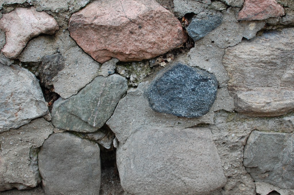
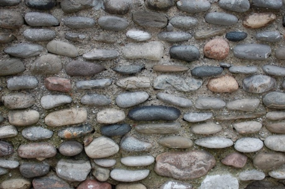
The retaining wall on this corner shows two obviously different building dates. The original wall consists of large pebbles of varying textures and colours but similar size – surely brought up from the beach – embedded in coarse, sandy mortar. A much newer wall of manufactured blocks, whose weight and smooth surfaces preclude the need for mortar, stands in places where the original has failed.
When one considers the time and skill required to craft the elegant, original wall – selecting the stones, setting them with a consistent horizontal orientation, and ensuring that the wall ends up strong, plumb, and securely adhered to the ground – one will recognize this as the work of a skilled bricklayer, almost certainly Jones himself. And walking a few doors down the hill one will see, first, that he built it in front of all four of his lots – he too, like Snider, demarked his land with stone, though he did so by his own hand and as a commercial landlord, not as a family patriarch. And second, that he went so far as to line the stairways up to two of his houses, one of them the house he built for himself, suggesting that he built the wall when or soon after he built that final house, about 1915. What we are seeing in this wall is the entrepreneurial working man as developer, builder, improver, and landlord, a combination of roles that produced innumerable Beaches houses (See Sights #7 and #10).
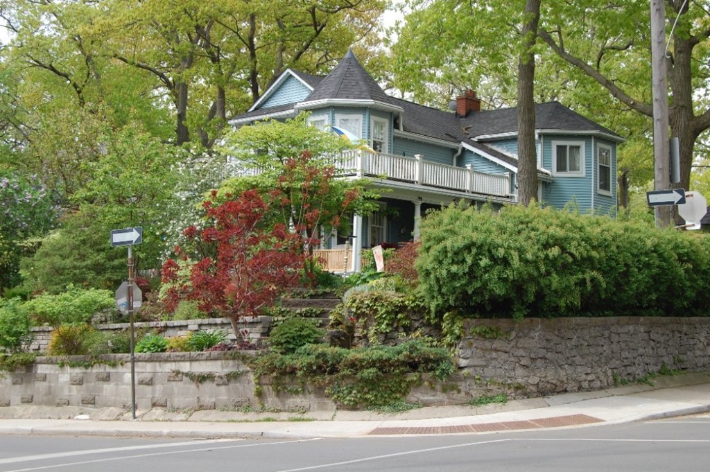
The house on the SOUTHWEST corner, unlike Snider’s and Jones’s, began life as a summer cottage, despite it being two long blocks from the lake and built rather late in the neighbourhood’s cottaging era. Its lot was one of 102 fifty-foot lots created in 1895 when two of Justice Wilson’s original partners, brothers James and Robert Beaty, further subdivided twenty of their jointly owned villa-size lots. The Beatys’ new lots sold slowly, but one that did sell, almost immediately, was this corner lot where in 1899 Dr. James Bray owned a good quality summer cottage. Whether one of the Beatys built the cottage and sold it to Bray or Bray bought the lot and had the cottage built for himself, records do not reveal.
We know that Dr. Bray lived and conducted his medical practice in a house on Gerrard Street East, so this must have been a seasonal residence. We also know, since much of the original house remains intact, that it had a large wrap-around main-floor porch, pine floors, an adequate brick foundation but no basement, a second-floor porch, and four fireplaces – two upstairs and two downstairs – all of which signal seasonal cottage rather than year-round home.

Of the eighteen lots shown here, only Lot 102 (Dr Bray’s Residence) had been sold.
For reasons that have escaped documentation, Dr. Bray sold the cottage in 1905 and disappears from neighbourhood records. Who wanted a summer cottage in the middle of a rapidly developing suburban neighbourhood in 1905? Nobody, it seems, because the buyer, a commercial painter named George J. Stanley who lived downtown at the time, made it his year-round residence. He would own it for some fifteen years and in that time appears to have carried out at least one major improvement – installation of a hot-water heating system with its boiler beneath the house in a partial, newly dug basement.
But it was still a cottage when, in 1920, Stanley’s widow chose to sell; it still had clapboard siding and a pre-building-code foundation, and probably the cold-weather draughts that come with such rustic features. This may explain why, over the next fifty years, the house went through multiple owners, people who, once they owned it, could not afford the substantial upgrades it needed. Not all these owners even lived in it – the house was occasionally rented – while some who did took in boarders. At least one, an otherwise unemployed widow, carved out a rental suite in the late 1920s, with its own street address, that remained in records, sometimes vacant, until the 1960s. Everything changed in the 1970s, of course, as old houses became chic rather than shabby and neighbourhood property values began to rise, and with this came owners who could afford major upgrades. The house began a new life, which continues to this day.
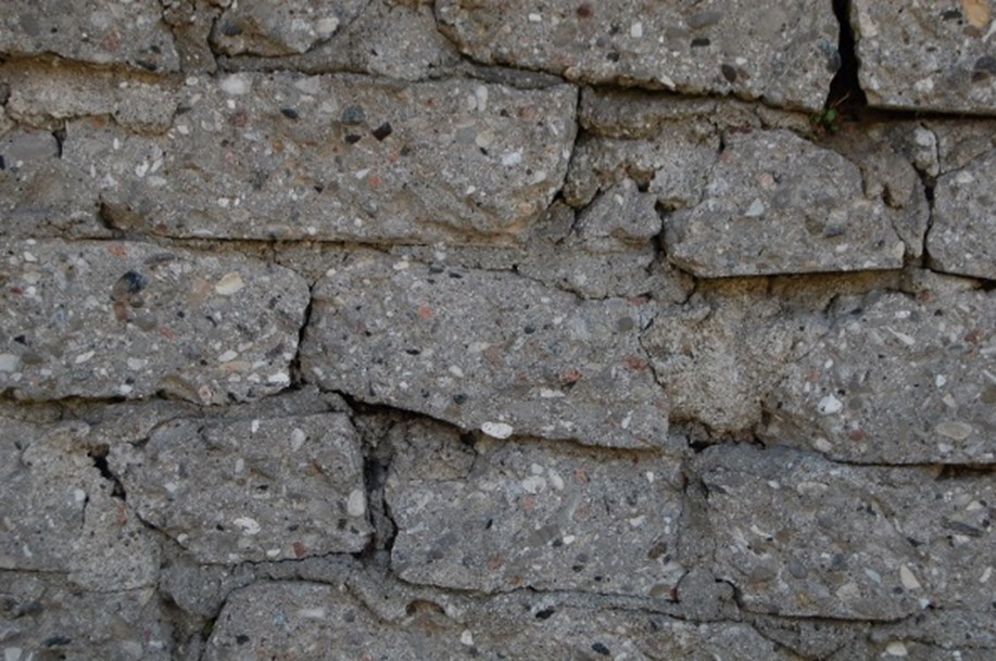
Its retaining wall is mostly a product of its earlier life. The portion facing Beech Avenue is something of a hodge-podge, having several forms, styles, and ages, reminding us that none of the house’s short-duration owners had the means or the desire to demark their property as Snider and Jones did. But the long stretch along Pine Avenue is another matter, an unusually well-preserved specimen of a little-known curiosity – a ‘stone’ wall made from pieces of broken-up sidewalk that the City offered to homeowners, apparently free of charge, when it broke up and re-laid old concrete sidewalks. The City must have built the entire wall, for it is on City property and who but the City would have such an enormous supply of broken-up sidewalk? But might something else have been in play? The flange at the wall’s base is date-stamped 1929, when the house was owned by the widow with the improvised rental suite. She almost certainly could not have paid for this wall’s construction. Did City officials realize that if they wanted a stable wall to protect their new sidewalk they would have to build it themselves? Is this wall telling us of past poverty, and the City’s response to it?
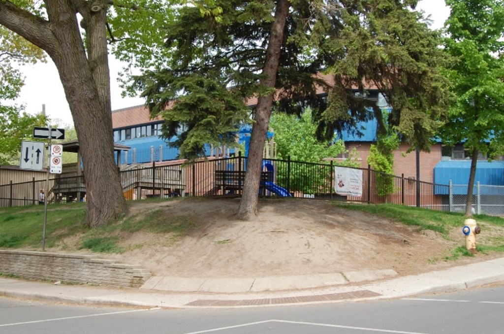
The NORTHWEST corner has a much simpler history. It has been unbuilt, as it is now, for most of the intersection’s existence. A large triangular block of land comprising villa-size lots 95, 96, and 100 (see Plan 406 detail, above) was subdivided into building lots by its owner, George Hogarth, in 1890, but these lots remained mostly unsold and unbuilt until 1906 when the local school board purchased five of them (5, 6, 7, 8, and 13) to build Pine Avenue, now Balmy Beach, school (see 1910 Goad’s, above).

A house was then built east of the school, but the corner, Lot 4, remained vacant until the early 1920s when its owners put up some small brick houses. These did not last, for in connection with a school expansion in the 1930s they were expropriated and demolished, leaving the corner open again and now in the hands of the school board. The corner remained essentially unchanged until the mid-1970s when the current school was built to replace the aging 1906 structure, and with the new school set further east on the lot and a fenced playground added beside its main entrance, the school board had no choice but to leave the corner unbuilt. And so it remains, fifty years later.
The oak trees, and perhaps the fire hydrant, might date from a century ago, but the retaining wall of factory-made concrete slabs along Pine is no older than the current school. Yet it cannot help but reveal some history: a well-maintained, utilitarian wall in front of a property an entire block long suggests one thing – longstanding public ownership.

SOURCES: (in addition to those cited under the images): CTA, Toronto Assessment Rolls and East Toronto Assessment Rolls (Series 749); Registered Plans of Subdivision #733 (1887), #1053 (1890), and #1183 (1895) [Ontario Land Registry]; Goad’s Atlas 1910, 1913, and 1924, accessed at website ‘oldtorontomaps’; “Sale of Park Lots at Balmy Beach,” The Globe, 7 Sept. 1878, p.6 (villa sales); interviews with current and past occupants of the houses at the corners (for which the author is very grateful); letter, 4 April 1974, H. Elgin Snider to Scott Snider, and photographs of the Snider cottage and house, all in the personal collection of Brian Snider; contemporary photographs by author.

A correction
The letter to Scott Snider was from H. Elgin Snider, his grandfather, not Harvey Snider, his great grandfather, who passed in 1947
LikeLike
Thanks Brian.
LikeLike
Herbert Jones a contractor and the son of the original builder of lots 33 and 34 died in 1988.
Herbert Jones and James Crawford on Oct 15 during hurricane hazel rescued people. A park in west Toronto off of Weston Rd was named in honour of them.
205 Beech Avenue was (apparently built in 1894) by Herbert Jones father. His wife visited the house many years ago and gave this info verbally to my friend that lived here before me. Cheers Liz
https://hurricanehazel.ca/ssi/your_stories_story16.shtml
https://toronto.citynews.ca/2006/08/29/local-park-dedicated-to-heroes-of-hurricane-hazel/
LikeLike
Very interesting. Thanks, Liz. Hurricane Hazel touched so many people in the region.
LikeLike