Before the Beaches was built up and its streets all graded and paved, the area was drained by several streams that flowed directly into the lake, some of them fairly substantial. Vestiges of their old watercourses, and of the wetlands they widened into on level ground, remain in the neighbourhood landscape – the old weeping willows along Kenilworth, the soggy ground of Ivan Forrest Gardens, and the beach-level grade of Silver Birch at the lake (See Sight #1) being three notable examples. But the run of townhouses on the west side of Waverley Road at Norway Avenue – whose novelty often draws the attention of passersby – is, rather surprisingly, another.
(colour depicts exterior wall material: orange=brick, yellow=wood)
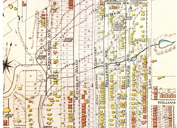
The northwest corner of the Beaches was built up rather late in the development process, more than a generation after the southwest. Owners of the land registered plans of subdivision early enough, well before 1900, and these plans laid out streets and building lots from Queen Street right through to Kingston Road. But only the southern portion of these subdivisions was built up; the northern portion, traversed by streams and valleys, was too wet and unstable for high-value, permanent buildings and builders generally avoided it. The valley of the largest stream, Norway Creek, which drained the high ground of the Ames estate to the east, was an especially dominant feature, being in places over a hundred feet wide. Maps show north-south streets running into the valley and across the creek, but with no bridges these roads were likely impassable in wet weather.
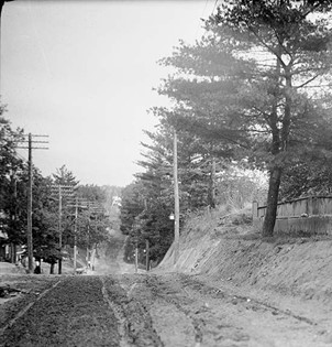
Looking north to where the road descends into the valley of Norway Creek(see Goad’s Atlas above) – Lee Avenue, on a decades-old road allowance, was the only road with a bridge across the creek.
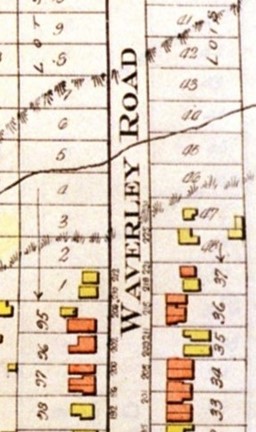
The impact of the terrain on Waverley Road is easy to see in the map detail to the right. As of 1913, housing had been built to the edge of the valley but no further; the most northerly houses on the west side – both wooden-clad – were on Lot 1 of a 1905 plan of subdivision. But housing demand was so strong that builders were beginning to push the limits, and in 1914 a builder bought Lot 2 and erected two substantial brick houses, one he rented and one he sold. The more northerly of the two – the one he sold – was rather precariously positioned, with its north-side foundation wall on the ravine bank, and in early 1917, less than two years after the house was built, that foundation wall collapsed. The house itself survived, for the rest of its foundation remained intact, but the owner had work to do.
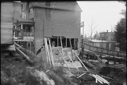
Looking south at the north wall. The use of poured concrete for foundation walls, as was done here, was comparatively new, and its limitations as a structural material were not yet fully understood.
At about this time the City decided to make Waverley a proper city street right through to Kingston Road by raising it on landfill through the creek valley. Why it chose to do this now, we cannot say. The City annexed the area in 1909 and had been upgrading the physical infrastructure ever since, so a road improvement such as this would not have been unexpected, but it seems possible that the foundation collapse, which the City Architect had investigated, spurred it to act. In any case, here was first step in burying Norway Creek.
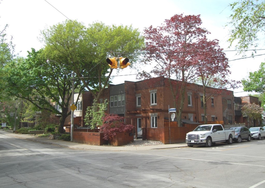
One immediate beneficiary of the City’s action was Harvey J. Barron, a local speculator/builder who had been buying and selling property in the area for several years and who, at this time, owned property immediately north of the house with the failed foundation, most of it ravine lots of little value for building. The new road transformed a portion of his holding – Lots 3 and 4 in particular – into good building lots on a permanent city street. Barron wasted no time exploiting this, erecting a run of eight attached townhouses on his two now-raised fifty-foot lots. He retained ownership and had tenants renting all eight by the end of 1918.
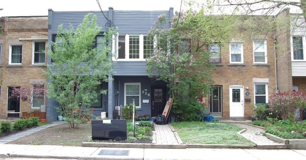
Barron’s decision to build townhouses, when every other builder in the neighbourhood was putting up either detached houses or pairs of small semi-detached houses, is hard to explain. They look so much like the ‘terraced’ housing built for the English working classes that one wonders if Barron was a nostalgic Englishman putting a little piece of England on his land. Or maybe he thought the location, for whatever reason, would appeal more to renters than buyers and that this form of housing suited the local rental market. He was also constrained by the depth of his lots. The City had raised the street, and only the street, meaning the lots sloped off sharply front to back. And since the land beyond the landfill was essentially still the original valley floor, and probably swampy, he was limited in how far back he could build. Might this have prompted him to build as densely as possible, with no space between the houses?
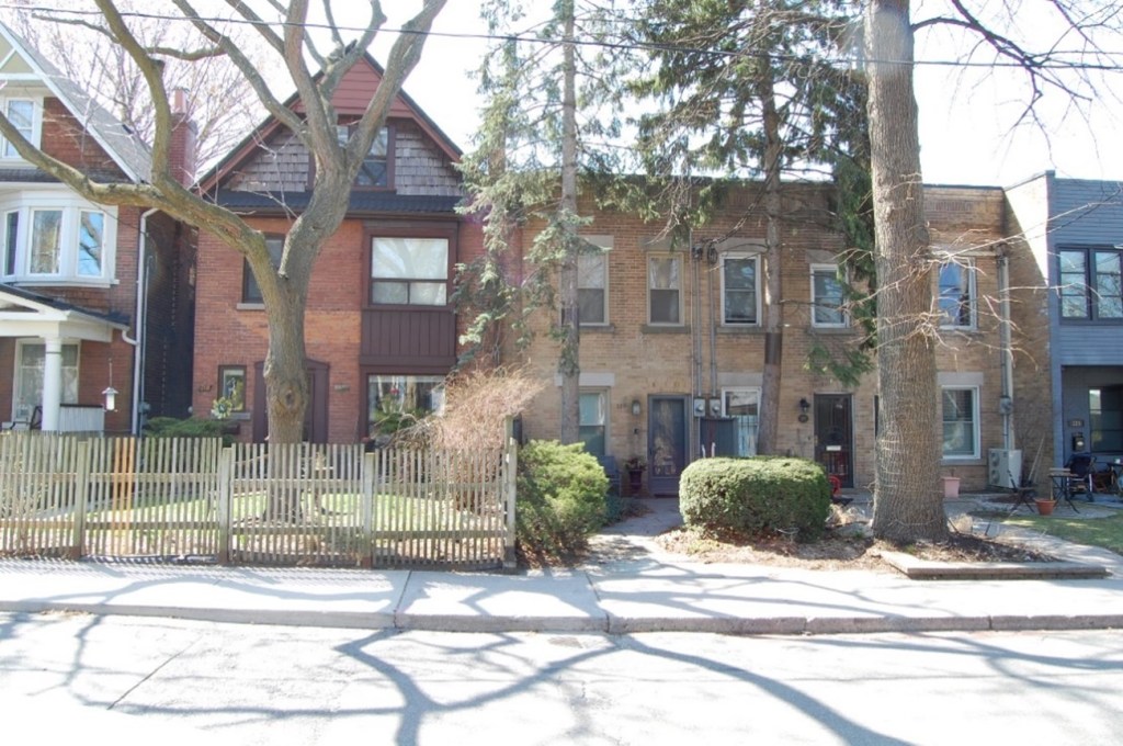
About a year later, in 1920, the City resolved to fill the rest of the Norway Creek valley, from Lee to Kenilworth Avenues, and to put a new street, Norway Avenue, across the neighbourhood on that fill. This required also raising the two other streets that crossed the stream, Wheeler and Bellefair, to the grade of the new street. It was, altogether, a major public undertaking – council repeatedly questioned its cost – that dispossessed several property owners and necessitated rebuilding dozens of private dwellings. The City carried it out in stages over several years.
Once again, Barron benefited. Filling the creek bed and creating Norway Avenue made his Lots 5 and (part of) 6 buildable, just as raising Waverley had for his Lots 3 and 4. And again he acted without delay, promptly putting up five more townhouses facing Waverley and, two years later, as the roadwork advanced, seven more around the corner on Norway. He had tenants in the Waverley houses by 1922, and the Norway houses by 1926.

Looking southwest from the new Norway Avenue to and beyond newly raised Bellefair Avenue, showing the depth of fill used; unsupervised children are everywhere in early twentieth-century urban photographs.
By 1926 Barron owned and rented out a nearly continuous, around-the-corner row of twenty townhouses – thirteen addressed on Waverley and seven on Norway – together with a large patch of unbuilt low-lying land behind them. The row was not fully continuous because when he built his second batch on Waverley he did not yet own a ten-foot strip of Lot 5 and had to leave it unbuilt (he acquired it in 1923). But this ended up being fortuitous because this ten-foot gap in an otherwise solid wall of housing provided the only access to the area behind the townhouses, and as the motor age advanced it became the driveway – once the back land was properly drained – to a place for townhouse residents to park their cars, as it is to this day.
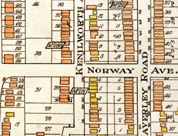
Barron’s thirteen Waverley townhouses appear here (Lots 3-6 – note small gap between Lots 4 and 5), as do several other small brick houses, built by other builders, that the newly graded streets allowed, but his Norway townhouses, built later along the un-expropriated half of Lot 6, do not.
The full story of what happened to these townhouses in the century after their construction is left for other researchers to discover. At some point either Barron – who moved into one in the 1930s – or his heirs sold them to individual owners, for they are all separate properties now. Most of them, clearly, have been renovated, inside probably even more than outside, but they and the terrain they occupy retain the form that Barron and the City’s Works Department created a century ago.
Another curious enduring feature of Barron’s undertaking is that he built his first townhouse right against, almost touching, the house whose foundation wall had collapsed, presumably to further stabilize that wall; he could do this because he had purchased (and repaired?) the house before building his townhouses.
One cannot say the form of these buildings is a product of Norway Creek’s disappearance. Harvey J. Barron could have built something else on his newly buildable lots, but he did not, for reasons we will never definitively know. Yet their existence is a product of that disappearance. Had the City not filled the creek and its valley there would probably be no permanent buildings of any sort at what is now the southwest corner of Waverley and Norway. And certain features of the buildings do reveal a connection to the creek-filling: their incongruity with houses to their south tells us they were built at a different time, their short front to back dimension and their deep rear sub-basements reflect the City’s limited landfill, and their commonality with each other suggests they were built nearly all at once on land suddenly made buildable. So these townhouses are, in a sense, artifacts of the disappearance of Norway Creek.
But where has the creek gone? We assume it was diverted into some sort of underground conduit – the accepted fate of Toronto’s long-lost creeks – but can we be sure? Might the patched-up cracks in the exterior brick of some Norway Avenue townhouses – suggesting shifting foundations – and residents’ stories of water pooling in the parking lot behind the townhouses – the erstwhile valley floor – be telling us it is still there, buried under piles of fill?
SOURCES: (in addition to those cited under the images): Registered Plans of Subdivision M28, M218, M215, M282, 898, and 984 [Ontario Land Registry]; CTCMs, various reports of the Committee of Works and Board of Control, 1919 to 1924, CT Bylaws 8374 (26 April 1920), 8452 (5 July 1920), and 9923 (25 Feb. 1924); CTA: Toronto Assessment Rolls, various years, and photographs, Series 372, Sub-series 3, Items 530, 541, 542, 552, and Sub-series 58, Item 933; Toronto City Directories, accessed through website of Toronto Public Library, digital city directories; Goad’s Atlases accessed through website ‘oldtorontomaps’; informal conversations and emails with residents; contemporary photographs by author.

Have lived at 50 Norway for almost 5 years now, and only just thought to do a little research on the neighbourhood. Great work. Thank you. I shall check out your other articles.
LikeLike