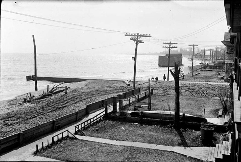
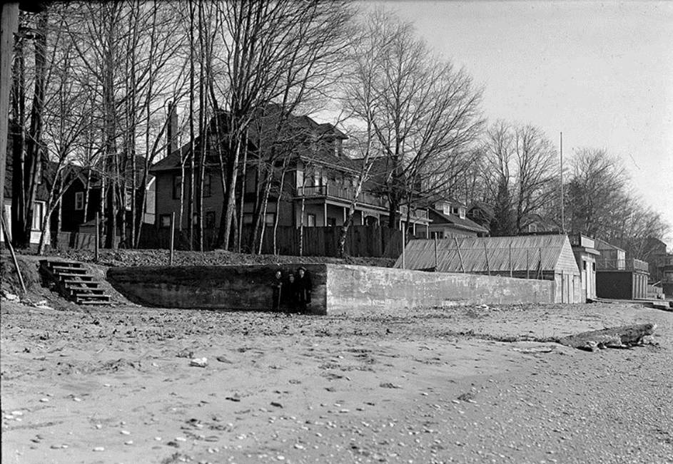
By 1920 the waterfront from Woodbine to Victoria Park was lined with private cottages, many of them on lots that included the beach and the land under the water several hundred feet into the lake (called water lots). A good number of these owners had built fences, walkways, and boathouses on their ‘front yards’ (even some who might not have had the legal right to do so). The beaches of the Beaches had become, in other words, very nearly a private domain.
[CTA, Fonds 1231, Item 933]
[CTA Fonds 1231, Item 1479]
The City was determined to bring this to an end – nobody had ever decided it should be this way – and in 1920, in concert with the Toronto Harbour Commissioners, it took the first step in making these beaches a public park by expropriating all the privately owned beach and water lots. The expropriation bylaws explicitly excluded one stretch of private land – the half-kilometre-wide beach and water lot in front of, and legally attached to, the property of the Scarboro Beach Amusement Park, a popular, privately owned attraction that the City had no desire to shut down. But when the street railway company that owned the amusement park closed it for good in 1925 and transferred ownership of its entire site to a residential developer, Provident Investments, the City quickly stepped in and purchased the property’s beach and water lots from the new owner. It paid a premium price, but the last thing the City wanted was a new residential enclave with a private beach, and it was willing to pay to ensure that such a thing did not appear.
After selling its beach and water lots to the City, Provident registered a plan of subdivision for what remained, still an enormous holding (see Sight #4). Their plan included a new street, Hubbard Boulevard, running east-west across the property’s southern edge, far enough from the now city-owned beach to allow building lots on both sides. Employing what was then common practice for residential development, Provident began selling its lots to commercial builders intending to build houses on them. Sales commenced in mid-1927, and among the first lots to sell were those along the south side of Hubbard Boulevard, notably a block of four (Lots 23-26) on the west end of Hubbard bought by Eliza J. Furniss who, with her husband, was an active builder/developer in the area. Even a cursory look at the plan of subdivision would have shown that houses erected on these lots, though fronting on Hubbard, would be effectively on the beach, and the City was concerned.
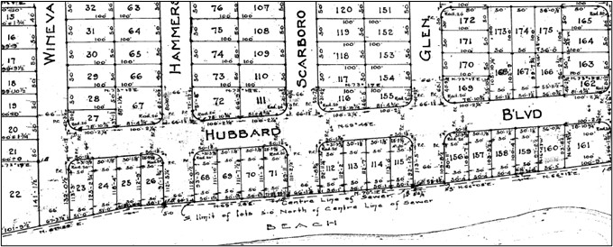
The plan laid out eighteen lots along the south side of Hubbard Boulevard; the Furnisses purchased Lots 23 to 26, on Hubbard, as well as Lot 22, fronting Wineva, on which they also built fourplexes.
Up to this point the City had expropriated only beach and water lots, not inshore property with cottages/houses on it, thinking, presumably, that this would be adequate for its new beach park. It was a questionable supposition, as a public beach lined with private cottages is not a very public beach, but the City evidently was prepared to leave existing cottages where they were, for now at least. New private dwellings on the beach, however, were another matter; these it certainly did not want. Yet here they were, about to appear. The City did nothing to halt the Furnisses – building houses on these lots was entirely permissible – but it could, and did, do something to stop further house building by expropriating, in September 1927, the fourteen remaining lots on the south side of Hubbard east of the Furnisses property, intent on incorporating them into the new public park.
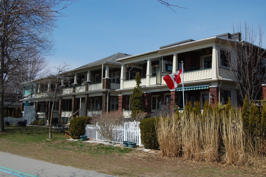
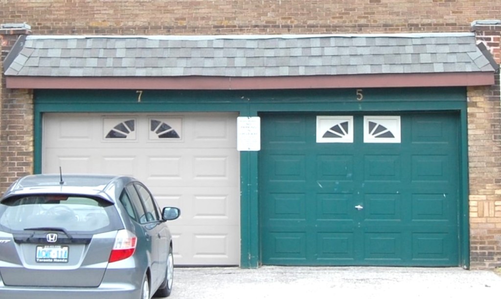
The Furnisses moved quickly, and by mid-1928 they had put up five buildings on their four lots: three ‘fourplexes’, one detached house, and one apartment building. This was probably not unexpected, for the City was by then resigned to having housing on these lots and this is what was being built elsewhere in the development. But what the City might not have expected is that, with no restrictions on where to put the front and back doors on what they built, the Furnisses put porches and front doors on the backs of the houses and garages and back doors on the fronts, producing a run of new houses which, although addressed on Hubbard Boulevard as per the plan of subdivision, was truly, unmistakably on the beach. The City had been thoroughly outfoxed.
This little drama has two curious epilogues. Two years later, in 1930, the City resolved to expropriate a strip of inshore property along the full length of the park – essentially to do what it had done here for the entire beach – and to demolish the more than one hundred private beachfront cottages and boathouses that had stood on that property for decades. This bold action was nothing less than cataclysmic for the neighbourhood, although it must be said that nearly doubling the park’s area with a swath of grassy land alongside the beach was a big step forward for the City’s public realm (see Sight #3).
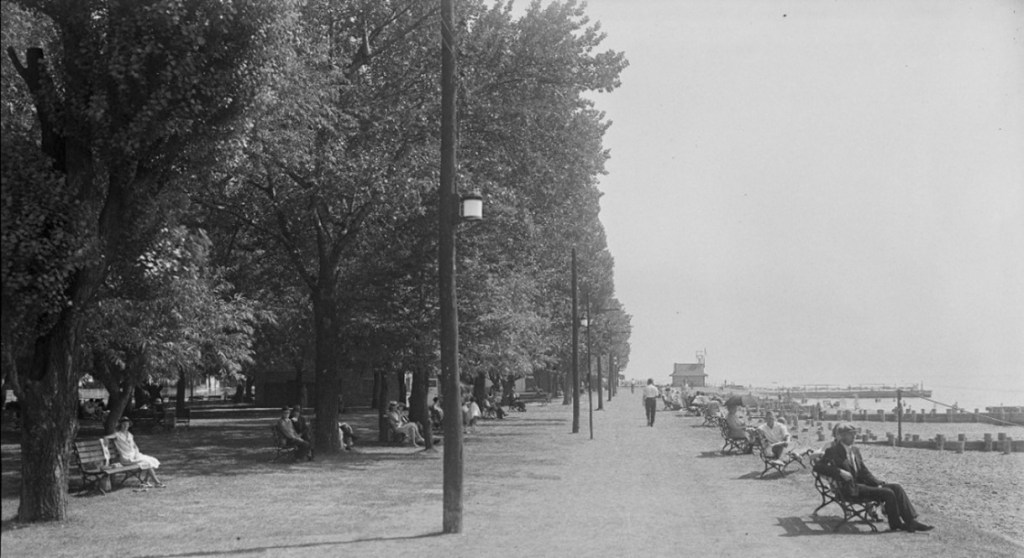
Beaches Park a year prior to opening, looking east from Waverley Road, 5 August 1931
But at the last minute the City decided not to demolish the eight new buildings that the Furnisses had put up in 1928 (they had built three facing Wineva as well). It had expropriated them along with everything else, but realizing they were new, well-built, and stylistically in keeping with adjacent housing, it opted to leave them, create the park around them, and rent them out as a revenue source. The City thus became landlord of the buildings it did not want. They stand to this day, most now returned to private ownership – a curious intrusion into a public park.
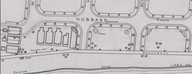
The City Parks Department designed the park around the new housing; the most northerly of the three new fourplexes on Wineva would soon be demolished for the extension of Hubbard, as depicted here.
Even more bizarre, in 2010 the buildings were “listed” on the City’s Heritage Registry, and in 2017 a few were formally “designated” with full heritage protection. One might wonder why this was done when they are surrounded by dozens of nearly identical buildings. And the answer is, according to a heritage report advocating their preservation – prepared without knowledge of the events narrated here – that they are unique in being “among the last surviving dwellings with direct access to the waterfront in Toronto’s Beaches neighbourhood.” This is true, strictly speaking, but it overlooks the critical fact that they were also the last such dwellings to be built, having been erected some thirty or forty years after the original waterfront cottages. They are not survivors of a bygone era; they were an attempt – thwarted after this one success – to halt the dawning of a new era, one in which the beach would be fully public. Perhaps they do warrant preservation, not as relics of the neighbourhood’s cottaging past but as reminders of public authorities being outfoxed by private builders.
SOURCES: (in addition to those cited under the images): The Toronto Harbour Commissioners, Toronto Waterfront Development 1912-1920 (Toronto 1912); Annual Report of the Toronto Harbour Commissioners for 1921/22, CTA, Series 60, Item 1493; “Plan Showing Lakefront from Woodbine Av. to East City Limit,” 19 Aug. 1920, CTA, Series 726, Item 275; “Scarborough Beach Park Water Lots, Etc., Purchase of,” CTCMs, 1925, pp. 919-20; CT Bylaws #8601 (20 Dec.1920), #8964 (19 Dec.1921), #11340 (26 Sept. 1927), and #12467 (27 Jan. 1930); “Conditions and Soundings – Woodbine Avenue East to City Limits,” 17 July 1929, CTA, Series 724, Item 205; “Hubbard and Wineva Properties,” City of Toronto, Staff Report, Summary, 4 March 2010; Heritage Register Map, accessed at City of Toronto website; contemporary photographs by author.
